More than a billion years of Earth's rock record is missing along a sharp geological boundary known as the Great Unconformity, where 540-million-year-old Cambrian sandstones rest directly on billion-year-old crystalline basement rock. Published in Nature, mantle-convection simulations by geoscientists at the University of Wollongong demonstrate that deep interior rock currents slowly lifted entire ancient continents during the Neoproterozoic Era for prolonged erosion before lowering them beneath rising seas.
What Is the Great Unconformity and Why Are Rock Chapters Missing?
Reconstructing deep planetary timelines from missing or preserved strata complements studies of ancient eclipse records and Ice Age footprints. In an unbroken geological sequence, younger sedimentary beds stack neatly atop older strata like pages in a book. Across much of the globe, however, that sequence suffers a massive interruption first recognized by John Wesley Powell in the Grand Canyon in 1869.
Along the Great Unconformity, shallow marine sedimentary rocks from the Cambrian period (roughly 540 million years ago, when complex animal life diversified) sit directly on top of deeply eroded igneous and metamorphic basement rocks that are often more than a billion years old. Depending on the continent, anywhere from 200 million to over one billion years of intervening Earth history is completely absent.
In a study published November 2026 in Nature (DOI: 10.1038/s41586-026-11156-5) and detailed by the University of Wollongong and ScienceDaily, PhD candidate Santosh Dhungana and Associate Professor Nicolas Flament tested whether slow vertical motions driven by Earth's convecting mantle can explain both the erasure and preservation of this boundary.
How Deep Mantle Convection Lifted and Lowered Ancient Continents
Understanding how extreme heat and pressure inside planetary interiors reshape surface rocks connects directly to research on extreme pressure phases and Mars organic carbon. Although Earth's mantle appears solid on human timescales, over hundreds of millions of years hot silicate rock circulates slowly like thick fluid. Upwelling plumes push overlying continents upward in a process called dynamic topography, while cooler downwellings pull continental interiors downward.
Dhungana and Flament built global geodynamic models spanning from the Neoproterozoic Era (roughly 1 billion to 540 million years ago) through the Phanerozoic eon (the past 540 million years). Their simulations revealed a striking two-step vertical cycle across three ancient continental cores: Laurentia (modern North America), Baltica (northern Europe), and North China.
During the Neoproterozoic, deep mantle upwelling elevated these continental interiors high above sea level. Kept aloft for hundreds of millions of years, glaciers, rivers, and wind stripped kilometers of older overlying rock off the continents, exposing ancient granite basement. Then, as mantle flow patterns shifted in the early Phanerozoic, those same continental regions subsided, allowing shallow Cambrian oceans to flood across the worn surface and seal the Great Unconformity beneath fresh marine sediments.
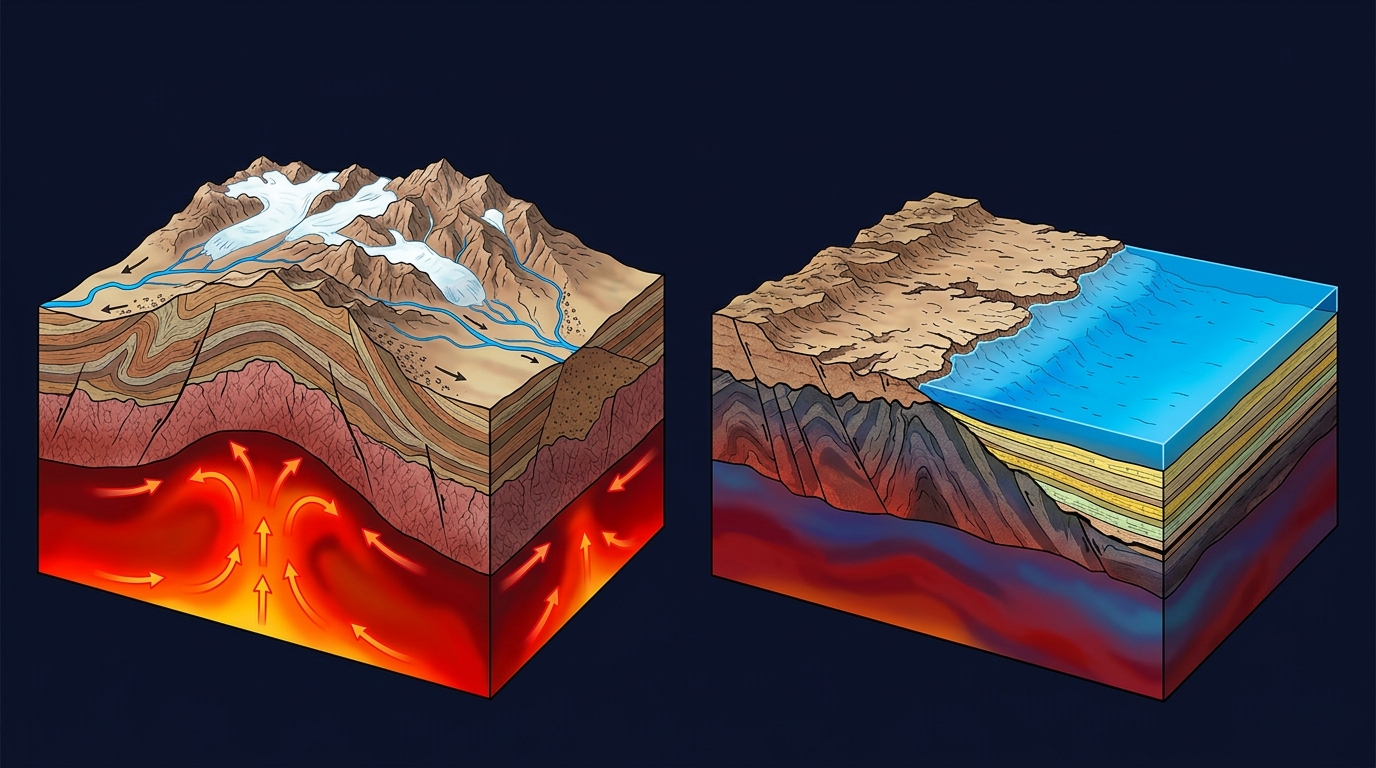
Comparing Snowball Earth Glaciation and Deep-Earth Uplift
Testing competing Earth-history hypotheses with quantitative models parallels advances in ancient DNA preservation, subcycle electron jumps, and fossil enamel proteins. For decades, many geologists attributed the Great Unconformity primarily to "Snowball Earth" Cryogenian ice sheets scouring the planet clean, or to tectonic collisions during the assembly of supercontinents.
While Flament notes that Cryogenian glaciers certainly acted as powerful erosive tools, ice alone cannot explain why the gap is so sharply preserved across specific continental cores. Without deep mantle upwelling lifting continents high enough to create steep erosional slopes, and without subsequent mantle-driven subsidence lowering them below sea level afterward, the eroded surface would never have been cleanly buried and preserved. The table below compares the leading hypotheses for the Great Unconformity.
| Geological Dimension | Snowball Earth Glacial Hypothesis | Supercontinent Collision Hypothesis | Deep Mantle Convection Model (2026) |
|---|---|---|---|
| Primary Driving Force | Global Cryogenian ice sheets grinding continental rock | Tectonic mountain building during Rodinia/Gondwana assembly | Long-wavelength dynamic topography from mantle flow |
| Mechanism of Erosion | Basal glacial scouring across broad landmasses | Regional weathering of localized collisional mountain belts | Prolonged continental uplift feeding glacial and river erosion |
| Geographic Match | Global climate event; does not explain regional preservation | Strongest along plate margins, weaker in continental interiors | Matches Laurentia, Baltica, and North China cratons |
| Preservation Mechanism | Post-glacial sea-level rise alone | Post-orogenic basin collapse near sutures | Phanerozoic dynamic subsidence sealing eroded surfaces |
| 2026 Nature Finding | Acts as erosive agent amplified by mantle uplift | Limited deformation at Laurentia's margins aids preservation | Single uplift-subsidence cycle reproduces sediment record |
Why Laurentia, Baltica, and North China Preserved the Record Best
One of the strongest validations of the University of Wollongong model is its geographic precision. Across Laurentia, Baltica, and North China, the simulations predicted the exact combination of prolonged Neoproterozoic uplift followed by steady Phanerozoic subsidence, matching the continents where the Great Unconformity is most extensively documented in outcrop and drill cores.
In addition, Laurentia's vast interior experienced relatively little tectonic deformation along its margins during this interval, allowing the clean contact between ancient basement granite and overlying Cambrian sandstone to survive intact in places like the Grand Canyon. By tying surface rock gaps directly to slow currents hundreds of kilometers underground, the study also offers a new framework for understanding how continental flooding and nutrient runoff shaped shallow marine habitats right before the Cambrian explosion.
Frequently Asked Questions
What is the Great Unconformity in geology?
The Great Unconformity is a widespread geological boundary where roughly 540-million-year-old Cambrian sedimentary rocks rest directly on crystalline basement rocks more than a billion years old, leaving 200 million to over one billion years of strata missing.
How does mantle convection cause continents to rise and sink?
Slow circulation of hot rock inside Earth's mantle creates dynamic topography, pushing continents upward above rising warm plumes and pulling them downward over cooler downwelling currents across hundreds of millions of years.
Did mantle convection alone erode the missing rock layers?
No. Mantle convection lifted the continents high above sea level during the Neoproterozoic Era, creating the elevation and slopes that allowed Cryogenian glaciers, rivers, and weathering to strip away older rock layers.
Which ancient continents showed the strongest Great Unconformity signal?
The University of Wollongong simulations predicted prolonged Neoproterozoic uplift followed by Phanerozoic subsidence across Laurentia (North America), Baltica (northern Europe), and North China, matching where the boundary is best preserved.
How was the Great Unconformity preserved instead of eroding away completely?
During the Phanerozoic eon, dynamic subsidence lowered the eroded continental interiors below sea level, allowing advancing Cambrian oceans to deposit protective layers of sand and mud over the worn basement rock.